Summit, Vail and Holy Cross 1:50,000 scale
4th Edition
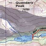
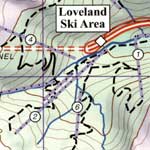
Excellent map covers a total of 18 USGS quad maps (9 on each side). Areas of note include the TenMile Range, Boreas Pass, Breckenidge, Frisco, Quandary Peak, the Colorado Trail, Copper Mountain, Vail, Beaver Creek, Minturn, Red Cliff, Eagle River, Gore Creek, Dillon, Silverthorne, Avon, Edwards, Mount of the Holy Cross, Camp Hale, Jacque Peak, Searle Pass, French Pass, Loveland Pass, Keystone and much, much more.
Map Features
- Waterproof, Tear Tough material for years of hands on use.
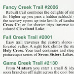
- 71 trail descriptions, trail ratings, & trail statistics. Numerous new & historical trails not shown on other maps.
- Full UTM grid with 2k spacing for ready use with GPS.
- Most accurate map for this area. Errors on other maps have been corrected.
- Most comprehensive map for this area.
- Improved hydrological mapping.
- Custom color tints create 3D effect.
- Shaded relief. 100ft contours.
|